
Geophysics
Environmental Geophysics
Geophysics
Geophysics is an earth science that evaluates physical properties to infer subsurface conditions. There are several geophysical techniques that exploit different properties. Every method has strengths and weaknesses associated with the physics that tailor to specific applications. Selection of the appropriate geophysical approach depends on the objective.
 Conductivity
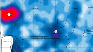
Subsurface ion concentrations (i.e. salts) greatly affect soil conductivity. As such, distributions of conductive soils can be delineated with frequency-domain electromagnetic induction methods, also called EM surveying. In oil and gas applications, ions tend to migrate further than associated hydrocarbons. Therefore, maximum impact extents can usually be determined with an EM survey.
A transmitter coil in the instrument emits an alternating electromagnetic field that induces eddy currents in the ground. Subsurface eddy currents produce a secondary electromagnetic field coupled to the primary field. Secondary field magnitudes are measured by a receiver coil that relate to bulk subsurface conductivity and indirectly correspond to ion concentrations. The instruments measure apparent conductivity, which implies that measurements do not directly represent the actual subsurface conductivity at any specific layer but yield a bulk representation of subsurface layers dependent on the electromagnetic properties of the soil.
 GEONICS EM38
The Geonics EM38 has an effective depth of penetration, or skindepth, of approximately 1.5 meters, and is often used in conjunction with the Geonics EM31 to obtain generalized depth information. The instrument has a shallower skindepth than the EM31, and a smaller footprint. As such, the tool will not detect deeper ion concentrations but will produce higher resolution maps and is less prone to interference from nearby electrical sources and metal infrastructure.
 GEONICS EM31
The Geonics EM31 has an effective depth of penetration, or skindepth, of approximately 5.5 meters, and is often used in conjunction with the Geonics EM38 to obtain generalized depth information. The instrument has a deeper skindepth than the EM38, and a larger footprint. As such, the tool will detect deeper ion concentrations but will produce lower resolution maps and is prone to interference from nearby electrical sources and metal infrastructure.
 GEONICS EM34
The Geonics EM34 has a variable effective depth of penetration, or skindepth, ranging down to approximately 60 meters. The instrument has a deeper skindepth than both the EM31 and the EM38, and a larger footprint. As such, the tool can detect deeper ion concentrations but will produce lower resolution maps and is more prone to interference from nearby electrical sources and metal infrastructure.
 Electrical Resistivity Tomography
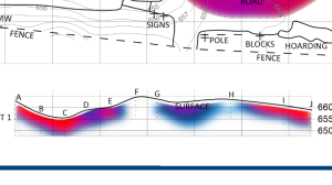
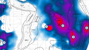
Lateral methods for determining subsurface conductivity, like EM surveys, yield very limited depth information, which can make it difficult to gauge the volume of impacted soil underground. Combining vertical conductivity methods with lateral conductivity data yields highly precise volumetric information of subsurface conditions.
Electrical resistivity tomography, also called ERT surveying, is a geophysical method that employs an electrode array at surface to record a series of electrical resistivity measurements along the line of investigation. From this information, some limited depth information can be inferred and imaged. Resistivity measurements at surface are correlated with their theoretical skindepths to produce a two-dimensional pseudosection of apparent resistivity. Numerical methods are then applied to the dataset, in a process called inversion, to create an approximate cross-sectional representation of subsurface conditions. A major advantage of ERT is that it does not require ground disturbance, but the method also has several drawbacks. First, overall soil conductivity greatly affects skindepth, meaning that the technology detects the depth onset of conductive layers rather than the depth extent. Second, image resolution drops as the depth of investigation increases, due to a well-know trade-off resulting from the properties of electric fields. Third, ERT suffers from the problem of equivalence, meaning that conductivity distributions at different depths can produce equivalent responses at surface. Despite these limitations, ERT can be cost-effective solution for visualizing generalized depth information.
Metal Detection
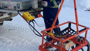
A common geophysical application is metal detection. Metals are inductive, meaning they conduct electric current when in the presence of a changing electric field. Due to this property, electromagnetic fields can be used to remotely detect buried metals.
The traditional and most reliable method for detecting buried metals is time-domain electromagnetic induction. A transmitter coil emits a primary electromagnetic field that switches on and off at discrete intervals. Receiver coils then measure the magnitude of the secondary (or transient) field as eddy currents decay in the target medium.
 Geonics EM61
The Geonics EM61 is a highly-sensitive, time-domain metal detector. The instrument measures the secondary field response at up to four different time intervals to provide a complete representation of the transient rate of decay. Since the rate of decay depends on target characteristics, this data yields some information on size and depth of potential targets. Late-time eddy currents occur predominantly within inductive materials, allowing the instrument to isolate responses from ferrous and non-ferrous metals. Depth of investigation ranges down to 5.5 meters, depending on the size and nature of the target.
 Magnetic Susceptibility
Frequency-domain electromagnetic induction methods can also be used to glean some information about potential metal targets. Instruments like the EM38 or EM31 measure two components of the secondary response. The first, and most frequently used, is the quadrature-phase that relates to apparent conductivity. The second measurement is the in-phase component. Reactive electrical properties in the soil, such as capacitance and inductance, shift the phase of the secondary field. In-phase magnitudes correlate to this shift, which represents magnetic susceptibility (a property of metals). EM instruments are not designed to detect metals; however, in-phase measurements can help differentiate between ion concentrations and buried metal responses. This feature is useful in some applications such as landfill assessments. When metal detection is the goal of the investigation, however, time-domain methods should be employed.
Our surveying procedure couples geophysical measurements with positional data, facilitating powerful imaging processes. The technology offers rapid data acquisition and instantaneous results. Target zone identification allows accurate analytical follow-up work to confirm geophysical findings. There are a variety of other geophysical methods suitable for a wide range of applications including environmental, exploration, and agricultural investigations. Proper geophysical method selection ensures target zones can be located and identified.