

Imaging
Environmental Imaging
Imaging
We produce preliminary maps instantaneously in the field. This allows for immediate sample targeting and investigation. The maps are georeferenced for instant positioning on mobile devices.
An important aspect of delineating anomalous regions during a survey is closure. Closure means that the surveyed area is extended in all directions until background (i.e. naturally occurring) levels are attained. Closed anomalies yield complete images of the impacted areas.
 Satellite Navigation
There are two Global Navigation Satellite Systems (GNSS) with worldwide coverage: the US Global Positioning System (GPS) and the Russian Global Navigation Satellite System (GLONASS). Either constellation is capable of sub-decimeter accuracies when differentially corrected for ionospheric effects.
Our rovers utilize and correlate both systems providing highly precise geographic positioning and redundancy in low signal areas. Nearby base stations supply differential correction data that broadcast in real-time via satellite to our receivers. Differentials measure the positional drift due to transmission delays in the ionosphere. Streaming differential telemetry eliminates post-survey processing and ensures immediate accuracy.
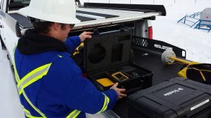
The positional receivers are synchronized with our geophysical instruments. Geophysical measurements are automatically paired and recorded with real-world coordinates. Data acquisition is precise, efficient, and readily uploadable for instantaneous in-field map creation.
Topography
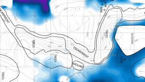
Topography is the study of forms and features of land surfaces. In common vernacular the word is usually restricted to contour maps that represent relief, but in a technical sense the study is much broader and includes all geographic representations of natural and artificial surface features. At Cascade we include point, area, and line features on all our maps to facilitate geotechnical interpretation.
Elevation data is often extremely useful for interpretation of site conditions and can be included as an overlay on geophysical maps. Topographic relief maps are graphic representations of Earth’s surface using contour lines to connect points of equal elevation. The method allows three-dimensional surfaces to be represented on two-dimensional maps.
 Altitude Positioning
Vertical positions are usually attainable with global positioning systems like GPS or GLONASS. Three-dimensional triangulation requires, at minimum, four reference points compared to two-dimensional positioning, which requires three. Therefore vertical positioning is approximately half as accurate as horizontal positioning. In areas where skyline obstructions limit satellite telemetry, altitude data sometimes must be forgone to acquire suitable horizontal coordinates.
 Georeferencing
Georeferencing refers to the process of embedding geospatial coordinates into digital image files. It relates aerial, satellite or geophysical imagery to geographical positioning.
At Cascade, we use GIS software to produce georeferenced maps in PDF format (GeoPDFs) for use with mobile device applications. Users can pinpoint their location on our maps through the GPS on their mobile device, facilitating rapid and accurate target identification without relative measurements to local surface features. We therefore make georeferenced field maps available immediately after survey completion so sampling and coring can proceed as soon as possible.
Photogrammetry
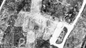
Aerial photography involves the production of images from an aircraft platform, such as an airplane, helicopter or drone. The term sometimes includes photography from artificial satellites as well, though the two methods differ somewhat in cost, resolution and update frequency. The technology is primarily intended for geographical cartography and reconnaissance but also has many geophysical applications. A process called orthorectification removes perspective distortions that are a by-product of camera optics by projecting the images onto a flat surface of uniform scale. Orthophotos permit georeferencing for use in mapping applications and GIS software.
 Orthomosaics
An orthomosaic is the product of a process that stitches multiple aerial photos together to produce a continuous, orthorectified representation of the Earth. Typically, we program waypoints into a drone to scan the area of investigation by taking a series of overlapping photos, which we then orthorectify and stitch together to produce the orthomosaic.
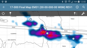
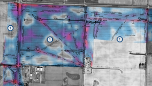
A useful application of aerial orthophotos for presenting geophysical findings is to overlay geophysical images on top of the aerial photograph. The relationship between geophysical results and subtle differences in terrain and surface features becomes apparent. To avoid interference with the image colour scale, we convert the aerial photograph in the background to greyscale and make the geophysical image transparent to reveal underlying surface features.
Our geophysical instruments are GPS synchronized for rapid data acquisition and images are immediately generated in-field. GPS synchronized geophysical data are imported into a Geographic Information System (GIS). GIS software allows the information to be georeferenced and graphed. Gridding algorithms interpolate levels between sample points to produce an image.
Maps are projected in Universal Transverse Mercator (UTM), so that distances are expressed in meters. These features make the maps easy to interpret and georeferencing allows for instant positioning on mobile devices. Site features are surveyed, drafted and included as an overlay on all maps. We also overlay sample points and walking lines to facilitate interpretation.